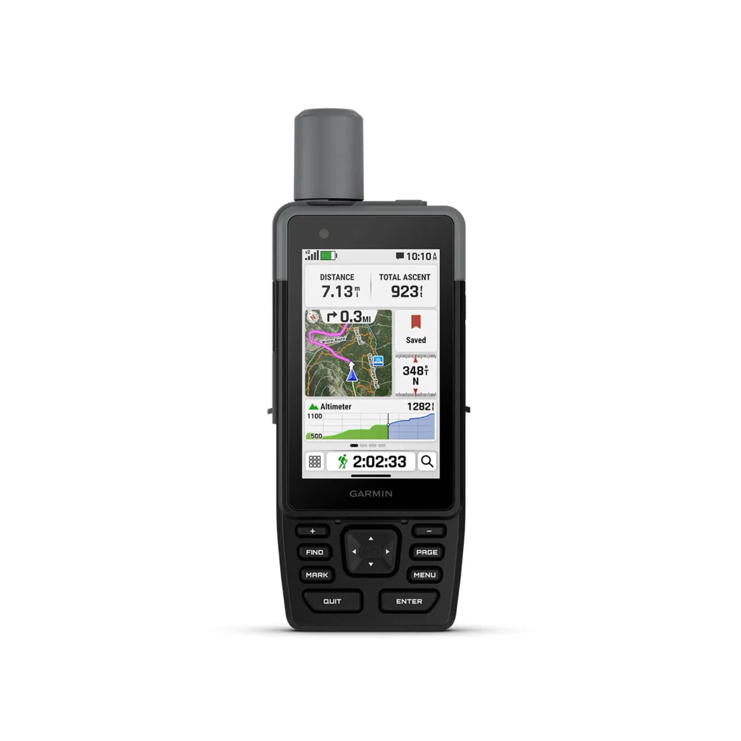
Garmin GPSMAP H1 Premium Handheld GPS Navigator
This rugged GPS handheld navigator has a modern design, preloaded maps, and incredible battery life. It’s time to hit the trails.
Touchscreen display
The bright, sunlight-readable 3.5-inch color touchscreen has chemically strengthened glass to resist scratches. It is glove-friendly, easy to see, and easy to use. Tap, zoom, and swipe on the maps to follow your route.
Physical buttons
The rugged hybrid design also features intuitive push buttons for more versatility when operating in weather and while wearing gloves. The quick-action button lets users customize functions to their specific needs.
Advanced navigation
Navigate with preloaded TopoActive maps for the U.S., Mexico, and Canada - and easy-to-access global maps. See terrain contours, elevations, geographical points, and more.
Satellite imagery
Download high-resolution photorealistic maps directly to your device via Wi-Fi technology. Find trails, pick stand locations and parking, create waypoint,s and more.
Outdoor Maps+
Purchase an Outdoor Maps+ plan for access to a variety of premium mapping content across the globe. The subscription is updated regularly and sent to your device over Wi-Fi.
Location accuracy
Get multi-band GPS and multi-GNSS support for superior positional accuracy.
Helpful tools
Use the built-in bright LED flashlight torch as a beacon or to light your way when the path goes dark. A loud built-in siren can help draw attention if you are in need.
Battery life
Long-lasting battery life allows for up to 145 hours in all Satellite Systems + Multi-band mode (assuming typical use with SatIQ technology) and up to 840 hours in Expedition mode.
Rugged design
Built to meet MIL-STD 810 for thermal, shock, water (IP67), and vibration to withstand weather and extreme temperatures.
On the go
This device has an integrated Spine Mount 2 and includes a removable loop carabiner for more versatility on your adventure. It's also compatible with additional Spine Mount 2 accessories, sold separately.
Garmin weather
Get real-time forecast information so you're aware of the changing conditions. Requires an active Wi-Fi connection, or an active cellular connection, and use of the Garmin Explore app on your paired compatible smartphone.
ABC sensors
Get a built-in altimeter for elevation data, a barometer to monitor weather, and a 3-axis electronic compass to provide direction.
Livetrack sharing
With Wi-Fi connection, or an active cellular connection and use of the Garmin Connect mobile app on your paired compatible smartphone, you can easily let friends or family follow your location while you're on the move; no need to point your device directly toward the sky to find satellites. They can see your progress, including distance, time, and elevation.
Plan your trips
Enjoy seamless trip planning with the ability to easily locate geographic points, share your route and more. This requires an active Wi-Fi connection or cellular connection with use of the Garmin Explore app on your compatible smartphone.
Garmin share
Easily share saved locations and courses with friends' compatible Garmin devices
Ascent planning
See upcoming climbs on your route, when they will occur, and how steep they will be.
Original: $599.99
-65%$599.99
$210.00More Images


Garmin GPSMAP H1 Premium Handheld GPS Navigator
This rugged GPS handheld navigator has a modern design, preloaded maps, and incredible battery life. It’s time to hit the trails.
Touchscreen display
The bright, sunlight-readable 3.5-inch color touchscreen has chemically strengthened glass to resist scratches. It is glove-friendly, easy to see, and easy to use. Tap, zoom, and swipe on the maps to follow your route.
Physical buttons
The rugged hybrid design also features intuitive push buttons for more versatility when operating in weather and while wearing gloves. The quick-action button lets users customize functions to their specific needs.
Advanced navigation
Navigate with preloaded TopoActive maps for the U.S., Mexico, and Canada - and easy-to-access global maps. See terrain contours, elevations, geographical points, and more.
Satellite imagery
Download high-resolution photorealistic maps directly to your device via Wi-Fi technology. Find trails, pick stand locations and parking, create waypoint,s and more.
Outdoor Maps+
Purchase an Outdoor Maps+ plan for access to a variety of premium mapping content across the globe. The subscription is updated regularly and sent to your device over Wi-Fi.
Location accuracy
Get multi-band GPS and multi-GNSS support for superior positional accuracy.
Helpful tools
Use the built-in bright LED flashlight torch as a beacon or to light your way when the path goes dark. A loud built-in siren can help draw attention if you are in need.
Battery life
Long-lasting battery life allows for up to 145 hours in all Satellite Systems + Multi-band mode (assuming typical use with SatIQ technology) and up to 840 hours in Expedition mode.
Rugged design
Built to meet MIL-STD 810 for thermal, shock, water (IP67), and vibration to withstand weather and extreme temperatures.
On the go
This device has an integrated Spine Mount 2 and includes a removable loop carabiner for more versatility on your adventure. It's also compatible with additional Spine Mount 2 accessories, sold separately.
Garmin weather
Get real-time forecast information so you're aware of the changing conditions. Requires an active Wi-Fi connection, or an active cellular connection, and use of the Garmin Explore app on your paired compatible smartphone.
ABC sensors
Get a built-in altimeter for elevation data, a barometer to monitor weather, and a 3-axis electronic compass to provide direction.
Livetrack sharing
With Wi-Fi connection, or an active cellular connection and use of the Garmin Connect mobile app on your paired compatible smartphone, you can easily let friends or family follow your location while you're on the move; no need to point your device directly toward the sky to find satellites. They can see your progress, including distance, time, and elevation.
Plan your trips
Enjoy seamless trip planning with the ability to easily locate geographic points, share your route and more. This requires an active Wi-Fi connection or cellular connection with use of the Garmin Explore app on your compatible smartphone.
Garmin share
Easily share saved locations and courses with friends' compatible Garmin devices
Ascent planning
See upcoming climbs on your route, when they will occur, and how steep they will be.
Product Information
Product Information
Shipping & Returns
Shipping & Returns
Description
This rugged GPS handheld navigator has a modern design, preloaded maps, and incredible battery life. It’s time to hit the trails.
Touchscreen display
The bright, sunlight-readable 3.5-inch color touchscreen has chemically strengthened glass to resist scratches. It is glove-friendly, easy to see, and easy to use. Tap, zoom, and swipe on the maps to follow your route.
Physical buttons
The rugged hybrid design also features intuitive push buttons for more versatility when operating in weather and while wearing gloves. The quick-action button lets users customize functions to their specific needs.
Advanced navigation
Navigate with preloaded TopoActive maps for the U.S., Mexico, and Canada - and easy-to-access global maps. See terrain contours, elevations, geographical points, and more.
Satellite imagery
Download high-resolution photorealistic maps directly to your device via Wi-Fi technology. Find trails, pick stand locations and parking, create waypoint,s and more.
Outdoor Maps+
Purchase an Outdoor Maps+ plan for access to a variety of premium mapping content across the globe. The subscription is updated regularly and sent to your device over Wi-Fi.
Location accuracy
Get multi-band GPS and multi-GNSS support for superior positional accuracy.
Helpful tools
Use the built-in bright LED flashlight torch as a beacon or to light your way when the path goes dark. A loud built-in siren can help draw attention if you are in need.
Battery life
Long-lasting battery life allows for up to 145 hours in all Satellite Systems + Multi-band mode (assuming typical use with SatIQ technology) and up to 840 hours in Expedition mode.
Rugged design
Built to meet MIL-STD 810 for thermal, shock, water (IP67), and vibration to withstand weather and extreme temperatures.
On the go
This device has an integrated Spine Mount 2 and includes a removable loop carabiner for more versatility on your adventure. It's also compatible with additional Spine Mount 2 accessories, sold separately.
Garmin weather
Get real-time forecast information so you're aware of the changing conditions. Requires an active Wi-Fi connection, or an active cellular connection, and use of the Garmin Explore app on your paired compatible smartphone.
ABC sensors
Get a built-in altimeter for elevation data, a barometer to monitor weather, and a 3-axis electronic compass to provide direction.
Livetrack sharing
With Wi-Fi connection, or an active cellular connection and use of the Garmin Connect mobile app on your paired compatible smartphone, you can easily let friends or family follow your location while you're on the move; no need to point your device directly toward the sky to find satellites. They can see your progress, including distance, time, and elevation.
Plan your trips
Enjoy seamless trip planning with the ability to easily locate geographic points, share your route and more. This requires an active Wi-Fi connection or cellular connection with use of the Garmin Explore app on your compatible smartphone.
Garmin share
Easily share saved locations and courses with friends' compatible Garmin devices
Ascent planning
See upcoming climbs on your route, when they will occur, and how steep they will be.